
J.E.Dyer exposes the fact that the most-breached sections of the US border fence with Mexico is located right where the ISIS camp in Mexico was reported in 2014.
Obama legacy: Outdated, damaged border fence at location of ISIS camp in Mexico
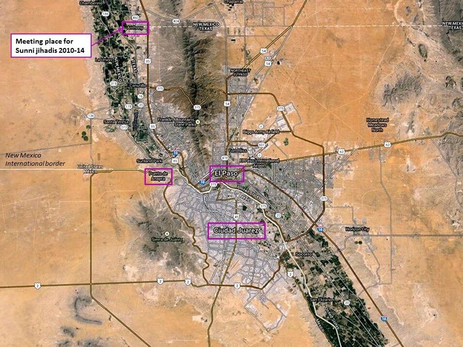
It’s always – always – essential to check a map.
That’s what we did here at Liberty Unyielding back in 2014 and 2015, when Judicial Watch published its scoop on the ISIS camp at the U.S.-Mexico border near El Paso.
The analyses from Judicial Watch and other websites emphasized how close the ISIS camp was to El Paso – understandably, given the co-location of Fort Bliss on El Paso’s east side, and the size of the U.S. and Mexican cities (El Paso and Ciudad Juarez) on either side of the border. Traffic at the border is heavy going both ways on a daily basis. The vulnerability for American security is obvious.

But if you laid it out on a map, the ISIS camp was much closer to the U.S. border (and a concentration of Americans) a little further west. The camp’s location was reported to be in Anapra, a suburb of Ciudad Juarez (see maps). Anapra lies less than two miles from the New Mexico town of Sunland Park.

The U.S. border fence – part of the 654 miles of it (covering about a third of the 1,954-mile border) – runs between the two towns. For a stretch of about a mile, the border fence is right at the northern edge of Anapra. I verified through local and social media sources that in this area, the fence is basically at the edge of some Anapra residents’ back lots.
In the April 2015 post linked above, I wrote about how designated “wilderness” areas in southeastern New Mexico were aiding illegal border crossers, including jihadis – who had a known presence as early as 2010 in and around the small New Mexican town of Anthony. The restrictions in the wilderness areas, some affected by President Obama’s more recent designations of adjacent “monument” areas, made it harder for the Border Patrol to maintain surveillance.